|
Quick Search
|
Search Results
You searched for: More Like: 'The Hardweird'
6 items
items as
Hardweird
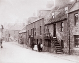
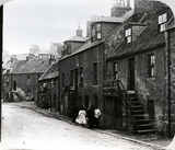
40 The Hardweird. Part of old Gilcomston, it resembled a small "ferm toon" standing between the foot of Jack's Brae and Upper Denburn and it consisted of 18th and early 19th century artisan and labourers' housing - a product of the period when Gilcomston had a flourishing weaving industry. One of Aberdeen's worst slums, it was cleared during the early 1930s and the playground of Gilcomstoun Primary School now occupies part of the site. Hardweird
718 The Hardweird, so named as having been built on the Hardweird Croft, is now the only street in Aberdeen showing the 'forestairs' that were so common in the older streets of the town. The Hardweird ran from Skene Row to Jack's Brae. Skene Row came off Skene Street, opposite Chapel Street. Part of old Gilcomston, it resembled a small "ferm toon" standing between the foot of Jack's Brae and Upper Denburn and it consisted of 18th and early 19th century artisan and labourers' housing - a product of the period when Gilcomston had a flourishing weaving industry. Some of the houses were demolished in 1908. One of Aberdeen's worst slums, it was cleared during the early 1930s and the playground of Gilcoumston Primary School now occupies part of the site. Upper Denburn and Hardweird
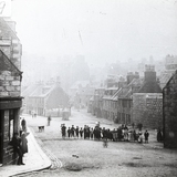
1515 This photo was taken from the bottom of Jack's Brae, looking eastwards. The road in middle of the photo is the Hardweird and the road to the left of the V-junction is Upper Denburn. (Brian Kennedy, Aberdeen)
The partially visible tenements on the skyline in he centre of this image are those at the junction of Skene Street and Rosemount Viaduct. St John's Well
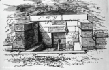
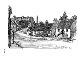
1849 St John's Well was situated at the junction of Skene Row and the Hardweird. Originally it was located on a grassy bank which led down from the bottom of Skene Row to Upper Denburn. The well took its name from being in a bit of land given for the support of a Chaplain of St. John the Evangelist in St Nicholas Church. Jack's Brae from the Hardweird
441 This image was digitised from Artistic Aberdeen: A Sketch Book (1932) by W. S. Percy.
The book describes the scene as follows:
"Jack's Brae, leading up from Hardweird. This name and street go back to the middle of the eighteenth century when the Council of the Burgh permitted the land to feuded out by "John Jack, manufacturer at Gilcomstone, at the yearly value of 8s. sterling." It was never, in actuality, a very pretty or charming part of the town, and is now less so than ever. Doubtless, in years soon to come, clearance schemes will include Jack's Brae; this drawing will be one of its best memorials." Hardweird
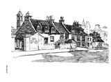
442 This image was digitised from Artistic Aberdeen: A Sketch Book (1932) by W. S. Percy.
The book describes the scene as follows:
"Hardweird, a curiously-named part of older Aberdeen, lies north-westward and parallel with Skene Street. The name can be traced to any certain extent only from the Hardweird Croft. At the junction of Hardweird and Denburn once stood one of the famous wells of the town, St. John's Well, which, on the building of Rosemount Viaduct in 1883, was moved and reconstructed. At one time this part of the town was a series of crofts. A remaining example of the forestairs to the old houses is an interesting feature of the drawing."
The tower in the background on the left is likely that of the Bon-Accord United Free Church on Rosemount Viaduct. The pyramidal spire to the right of the skyline will be that atop the tenement at 46 Rosemount Viaduct. This suggests that the dwellings shown here are those that stood on the north side of Hardweird, between it and Upper Denburn. This sketch looks north-northeast. |


