|
Quick Search
|
Search Results
You searched for: Subject matches "Ferryhill" or its children
33 items
items as
 
Allenvale Cemetery from Kincorth
60 An early photograph of Allenvale Cemetery, taking shape in the middle distance, as seen from Kincorth, with Abbotswell Farm in the foreground.
A limited company called the Aberdeen Cemetery Company was established for the purpose of creating this new graveyard. A prospectus inviting public investment was published in the Aberdeen Journal of 29th January 1873. It reads as follows:
"It is well known that in Aberdeen cemetery accommodation is limited and insufficient, and it is generally admitted that its extension is necessary, and cannot much longer be delayed. It is therefore desirable to acquire additional space for that purpose, and to treat it in accordance with modern ideas and practice.
"This company has been formed for the purpose of providing an extensive Cemetery, in the neighbourhood of Aberdeen, suitable in all respects for the purposes of internment, and of easy access - but sufficiently removed from town to preserve its suburban character."
The new cemetery opened in late 1874 and, as we know, was a big hit. It was officially known as the Aberdeen Cemetery but quickly became known as Allenvale Cemetery, after the property on which it was built.
Allenvale saw major extensions in 1912 and 1932. A London syndicate purchased control of the graveyard from the Aberdeen Cemetery Company in 1958. Aberdeen Town Council subsequently took control of the cemetery in 1965 following the then owners going into liquidation and worries about Allenvale's future. Allenvale remains a fine example of a planned Victorian cemetery to this day.
Notable residents of Allenvale include John James Rickard MacLeod (1876-1935), co-discoverer of insulin, James Scott Skinner (1843-1927), fiddler and composer, and Mary Esslemont (1891-1984), the influential doctor. Though, of course, many interned at Allenvale would have their own interesting stories to tell.
In this photograph, Duthie Park, later created on the right, has yet to be landscaped. St. Machar Poorhouse, Fonthill House and Devanha House can all be seen in the distance. 
Old bed of River Dee
314 This photograph looks east from the field below Devanha House, roughly where the street Devanha Gardens East stands today, towards the River Dee and Torry beyond. The image shows the old river bed prior to its diversion in 1869.
Prospect Terrace can be seen at the end of the field and beyond this lane are buildings of the Devanha Brewery and some nearby houses. The archways that can be seen on the left are part of the viaduct for the Caledonian Railway heading north towards the nearby Guild Street stations.
The open archway is likely where Wellington Road, now South College Street, passes under the railway. Much of this viaduct can still be seen today and remains how trains reach the city centre from the south. 
Aberdeen Station and the Ferryhill Junction
553 Aberdeen Station railway lines at the Ferryhill Junction. Note the construction of St. Nicholas House in the centre of the photograph. This photograph dates from around 1968. 
Duthie Park
2192 A postcard image, likely from the early 20th century, looking east across the northernmost section of Duthie Park's Upper Lake, towards the bandstand.
As can be seen on old large scale Ordnance Survey maps, the northern section of the lake was originally lobed shape as visible here. It was made more cohesively rounded at some point in the mid-20th century.
This part of the Upper Lake has traditionally been used for pedalos. 
Riverside Road, Aberdeen
2722 An Adelphi Real Photograph Series postcard showing Riverside Road. This road is now known as Riverside Drive.
The railway viaduct over the River Dee can be seen in the distance of the image. This photograph was taken south east of Duthie Park.
A cyclist wearing a boater hat can be seen in the centre of the image and two men with a cart are in the distance. 
Dee Village Electricity Works
2872 A photograph taken in April 1901 showing the land cleared in preparation for the construction of the Dee Village Electricity Works.
This image was taken from the bottom of Crown Street looking east. Milburn Street is on the right and the now demolished Dee Village Road is on the left. A steam train can be seen on the Wellington Road, later to be South College Street, viaduct in the middle distance.
The premises of Charles R. Fraser, paperhanger and decorator, can be seen in the foreground. Signs on the shop's windows indicate that it is moving the following month to 127A Crown Street.
This image is from an album of photographs held by Aberdeen City Libraries detailing the construction of the Dee Village Electricity Works. 
Dee Village Electricity Works
2875 A photograph showing the western elevation of the Dee Village Electricity Works under construction on 30th September 1901. This image was taken from the bottom of Crown Street and looks east.
Walker Road Primary School in Torry can be seen in the distance on the horizon, a bit right of centre. It was opened on 8th March 1897.
This image is from an album of photographs held by Aberdeen City Libraries detailing the construction of the Dee Village Electricity Works. 
Dee Village Electricity Works
2881 A photograph showing the western elevation of the Dee Village Electricity Works under construction on 19th August 1902.
The building's impressive facade on Millburn Street, with its gable reading "Corporation Electricity Works" and the Aberdeen's coat of arms, can just be seen to the right of the image.
This image is from an album of photographs held by Aberdeen City Libraries detailing the construction of the Dee Village Electricity Works. 
Dee Village Electricity Works
2882 A photograph showing the construction of the chimney at the Dee Village Electricity Works taken on 24th August 1901. The original plans for the works included a 200 foot chimney and, due to its location in a residential area, it was one of the relatively few points of contention in the scheme.
The function of the chimney was to release waste fumes created by the work's boilers. The chimney was fitted with a Green's Economiser near its base. This was then a common feature of industrial chimney and its function was to pre-heat boiler feed water using waste fumes. The Dee Village works had the biggest economiser in the city at the time.
The chimney was demolished after the works were closed in February 1969 and the turbine hall was replaced by an office block.
This image is from an album of photographs held by Aberdeen City Libraries detailing the construction of the Dee Village Electricity Works. 
Dee Village Electricity Works
2883 A photograph showing the newly constructed interior of the Dee Village Electricity Works taken on 20th March 1901.
An electric conveyor belt with carts, and later a railway, brought vast quantities of cheap-quality coal from storage bunkers to heat the station's boilers. John S. Reid in Mechanical Aberdeen (1990) states that up to 20 tons of coal an hour was supplied to the furnaces.
Each boiler is marked "Aberdeen Electricity Works", is numbered, and has the date of installation - 1901. The figure to the left of the image looks like James Alexander Bell, the City Electrical Engineer.
This image is from an album of photographs held by Aberdeen City Libraries detailing the construction of the Dee Village Electricity Works. 
Dee Village Electricity Works
2885 A photograph showing the eastern side of the Dee Village Electricity Works under construction on 28th December 1901.
On 2nd November 1901, as the facility was being built, it was found necessary to start operating the works early to meet the increasing demand for electricity. This was achieved with the construction of a temporary wooden engine-room and boiler-room that was replaced as building progressed. The wooden structure shown here is most likely the temporary engine room.
This image is from an album of photographs held by Aberdeen City Libraries detailing the construction of the Dee Village Electricity Works. 
Aberdeen Cable Subway
2887 This photograph shows the Aberdeen Cable Subway under-construction in around 1901. The subway was constructed as part of the Dee Village Electricity Works.
It was designed as a clever way to supply electricity to key areas without either unsightly overhead cables or repeatedly digging up of the streets. It was installed at a cost of £18,661 and was eight feet high by four feet eight inches wide. It runs up Crown Street, turns along Langstane Place and horse-shoes into Holburn Street.
It was designed with room to add cabling as demand increased. In order to minimise disruption, the subway was installed at the same time as a new sewer located below. The cable subway is still there today and remains one of many intriguing subterranean features of the city. The subway's ornate Art Nouveau ventilation shaft can be seen at the western end of Justine Mill Lane.
This image is taken towards the bottom of Crown Street. The buildings in the distance are those on the south side of Millburn Street at its junction with Crown Street. In the mid distance can be seen the lone standing premises of Charles R. Fraser, paperhanger and decorator. The view in this image would later to blocked with the construction of the electricity works and connected tram depot.
This image is from an album of photographs held by Aberdeen City Libraries detailing the construction of the Dee Village Electricity Works between 1901 and 1903. 
Dee Village Electricity Works
2888 This photograph shows the Dee Village Electricity Works under construction on 6th January 1903. It shows the combined steam engines and dynamos being installed in the work's engine room.
John S. Reid in Mechanical Aberdeen (1990) explains that, once completed, the engine room, 126 feet long by 62 feet wide, housed eight combined steam engines and dynamos. These enabled the plant to supply 3,810 kilowatts for lighting, heating, power and tramway traction purposes.
Correspondent Ed Fowler suggests the two steam engines and dynamos shown in this image are likely those installed and active in a temporary wooden engine room as the final hall was constructed surrounding it. The generating sets look to be at a higher position than the final layout and would need to have been lowered in due course.
This image is from an album of photographs held by Aberdeen City Libraries detailing the construction of the Dee Village Electricity Works between 1901 and 1903. 
Dee Village Electricity Works
2889 This photograph shows the engine room of the Dee Village Electricity Works on 4th March 1903 as it nears completion.
In addition to the electricity generating machinery the works included a suite of airy, brightly-lit offices, including an inquiry and waiting-room, a clerk's room, chief clerk's room, drawing office, manager's room, staff room, station engineers' room, a testing room, mains room, lavatory and bathroom. As can be seen in the photographs, the manager's and station engineers' rooms each had large windows overlooking the engine room and access via an iron platform and stairway.
The offices and the engine hall occupied the southern section of the works facing south on to Millburn Street.
This image is from an album of photographs held by Aberdeen City Libraries detailing the construction of the Dee Village Electricity Works between 1901 and 1903. 
Dee Village Electricity Works
2890 This photograph shows the engine room of Dee Village Electricity Works on 13th March 1903 as it nears completion.
This image is from an album of photographs held by Aberdeen City Libraries detailing the construction of the Dee Village Electricity Works between 1901 and 1903. 
Dee Village Electricity Works
2891 This photograph shows the finished engine room of the Dee Village Electricity Works on 29th January 1904.
In addition to the engine room and the suite of offices, the windows of which can be seen towards the rear of this image, the works also included a boiler-house, battery-room, economiser house, pump-room and a large chimney.
This image is from an album of photographs held by Aberdeen City Libraries detailing the construction of the Dee Village Electricity Works between 1901 and 1903. 
Dee Village
2892 This photograph shows the Dee Village residential area at the bottom of Crown Street in 1898, shortly before it was demolished to make way for a new municipal electricity works constructed between 1901 and 1903.
The photograph looks towards the north west and Crown Street can be seen in the background. The later to be demolished Dee Village Road is in the upper right of the picture.
This image is from an album of photographs held by Aberdeen City Libraries detailing the construction of the Dee Village Electricity Works. 
Dee Village Electricity Works
2893 This photograph shows the eastern side of the finished engine room in the Dee Village Electricity Works on 29th January 1904. It comes from an album of photographs held by Aberdeen City Libraries detailing the construction of the Dee Village Electricity Works between 1901 and 1903. 
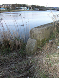
March Stone Alpha
3176 This stone is located on the north end of the parapet over the mouth of Ferryhill Burn at River Dee, opposite Old Ford Road.
It is marked "A ABD CR". The Alpha stone, as the name suggests, is the geographically first in the sequence of Aberdeen's primary boundary stones.
A slide of this image was kindly lent to Aberdeen City Libraries by Colin Johnston so that we could create a digital copy for public use.
The image was taken in the early 1980s when Colin worked as a teacher at Bridge of Don Academy. He led several current and former pupils, and staff members, in an investigation into the location, physical condition and public knowledge of Aberdeen's historic boundary markers. 
March Stone 2
3178 This 1980s photograph shows stone number 2 flat in the pavement outside the entrance to Ferryhill Library. Subsequent redevelopment of this area has seen the same stone move to a grassy area between the new car park and the roundabout.
The Blue Book indicates there is no description of the marker from the 1525 perambulation. It does however give a 1698 description, as taken from Kennedy's Annals of Aberdeen (1818):
"Therefrae, ryding in the Hardgate to the house called the Halfpennie house, where there is a march-stone, with an sauser, at the north-west side of said house, on the brink of the burne."
It also notes that the stone was missing at the Riding of the Marches in 1889, but had since been replaced.
A slide of this image was kindly lent to Aberdeen City Libraries by Colin Johnston so that we could create a digital copy for public use.
The image was taken in the early 1980s when Colin worked as a teacher at Bridge of Don Academy. He led several current and former pupils, and staff members in an investigation into the location, physical condition and public knowledge of Aberdeen's historic boundary markers. 
March Stone 3
3179 This stone is located against the cemetery wall at the corner of Nellfield Place and Great Western Road. It remains at this location in 2020. The large paving slabs seen here have been replaced by smaller paving blocks. It is marked '3 ABD'.
Kenndy's Annals gives the following description from 1698:
"Therefrae, to the houses at Cowperstown, where there is an sauser stone, two ells or thereby from the south-east gavel of the west most house."
In 1780 it is described as "a large earthfast stone in the North West corner of Mrs Cochrane's Parks of Ferryhill...".
Both this and the nearby number 4 stone are recorded on the Ordnance Survey 1868 large scale map of Aberdeen.
A slide of this image was kindly lent to Aberdeen City Libraries by Colin Johnston so that we could create a digital copy for public use.
The image was taken in the early 1980s when Colin worked as a teacher at Bridge of Don Academy. He led several current and former pupils, and staff members in an investigation into the location, physical condition and public knowledge of Aberdeen's historic boundary markers. 
Alpha March Stone
3490 A photograph from early-2020 showing the Alpha March Stone at the north end of the parapet over the mouth of Ferryhill Burn at the River Dee, opposite Old Ford Road. |