

|
Quick Search
|
Search Results
You searched for: Subject matches "Cottages" or its children
38 items
items as
  at South Stocket")
Arrucarias (Monkey Puzzle trees) at South Stocket
12 Arrucarias (Monkey Puzzle trees) at South Stocket 
Cottages with drystane dyke
22 Stoneyton, old Skene Road, approximately 300 yards west of Albert Street. Demolished 1875-76 to build part of Carden Place. The houses depicted in the above picture are listed in the Post Office Directory of 1873/74. The thatched building on the left was used as a blacksmiths shop and the other buildings were inhabited mostly by Rubislaw Quarry workers. They were demolished to make room for the erection of modern villas about 1879. 
Honeybrae House
96 Honeybrae House. This house stood in the middle of a market garden near Morningfield Hospital about one-and-a-half miles west of Aberdeen City Centre. The lands were part of the old royal hunting forest of Stocket, given to the town of Aberdeen by Robert the Bruce. In the 17th century, it came into the ownership of the Skenes of Rubislaw and, in 1875, it was owned by Aberdeen Land Association. This two-storeyed house is most famous for its connection with the poet Lord Byron. In 1798, as a boy of about 10, he was taken there to spend a summer holiday while he was a pupil at Aberdeen Grammar School. At that time, it was probably a fairly new house, standing in its own grounds in a rural situation. He stayed there with his mother and their maid, Isabella Mitchell, before going to visit his old nurse, Agnes Gray. His room was on the first floor. By the 1830s, it was the home of a Captain John Boyd and later of market gardeners. Above the main door, there was a window whose thirteen small designed panes led it to be called 'the thirteen' window. By the 1920s, it had fallen into disrepair and the house was demolished in November 1928. The site was redeveloped for modern housing. 
Villa Franca
109 Villa Franca, built by Mr. Peacock, dancing master, who died in 1806. The name has been transferred to No. 156 Hamilton Place, which partly stands on the site of the former house, a little east of Morningfield. 
Stoneyton Clachan, Aberdeen. c.1875
381 This group of old houses, identified as Stonytown on some old OS maps, with ashtrees in front, stood on the north side of the road which led from the city westwards towards Skene.
This street is now called Carden Place and the houses were just west of its junction with Prince Arthur Street. They were demolished about 1879 to make way for modern houses.
The thatched building at the left was a blacksmith's and the red tiled houses were occupied by various tradespeople - gardeners, joiners and a bleacher. Plus workers at Rubislaw Quarry. The central house shows the old style outside stair leading to the upper floor.
The roadway between the cottages ran via a wooden bridge over the Denburn towards Fountainhall Road. 
Stoneyton Clachan, Carden Place
728 Stoneyton Clachan. This group of old houses stood on the north side of the Skene Road, now called Carden Place, west of its junction with Prince Arthur Street. They were demolished to make room for modern villas around 1879. The cottages were mostly inhabited by Rubislaw Quarry workers. 
Stoneyton, Old Skene Road
1451 Stoneyton, old Skene Road, approximately 300 yards west of Albert Street. Demolished 1875-76 to build part of Carden Place. The houses depicted in the above picture are listed in the Post Office Directory of 1873/74. The thatched building on the left was used as a blacksmiths shop and the other buildings were inhabited mostly by Rubislaw Quarry workers. They were demolished to make room for the erection of modern villas about 1879. 
Springfield Cottage
1477 Springfield Cottage as seen from Springfield Road looking north west. The photograph was likely taken during the 1950s at which point the cottage was on the outskirts of the city.
The residential development we know as Craigiebuckler had yet to be built. The line of trees in the background is that of Craigiebuckler Avenue. If we turned the camera some degrees to the north we would have a view of Craigiebuckler Parish Church and its halls.
The cottage was most likely demolished as part of the aforementioned residential development.
(Many thanks to A. G. Duthie for information on the location of this cottage). 
Westerton and Caiesdykes Farm
1478 This image has not yet been indexed. Use the Comments button below the image to enter information about the photograph.
Please note: we will not include any personal information provided unless you indicate that you wish to be acknowledged. The standard form for crediting your information is (name, place) e.g. (John Smith, Aberdeen). 
Raeden Farm
1480 This image has not yet been indexed. Use the Comments button below the image to enter information about the photograph.
Please note: we will not include any personal information provided unless you indicate that you wish to be acknowledged. The standard form for crediting your information is (name, place) e.g. (John Smith, Aberdeen). 
Silverhillock Farm
1482 An image looking north east showing Silverhillock Farm in the 1950s.
The property, through which flowed the Gilcomston Burn, was located at the junction of Westburn Road and Foresterhill Road.
The Royal Infirmary buildings can be seen in the background. 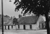
1488 This image has not yet been indexed. Use the Comments button below the image to enter information about the photograph.
Please note: we will not include any personal information provided unless you indicate that you wish to be acknowledged. The standard form for crediting your information is (name, place) e.g. (John Smith, Aberdeen). 
Craigton Road Steading
1489 This image has not yet been indexed. Use the Comments button below the image to enter information about the photograph.
Please note: we will not include any personal information provided unless you indicate that you wish to be acknowledged. The standard form for crediting your information is (name, place) e.g. (John Smith, Aberdeen). 
Mastrick Cottage
1497 A photograph of Mastrick Cottage in 1951. This was likely part of Mastrick Farm. It was located just on the southern side of Mastrick Road. 
Hirpletillim
1525 Hirpletillim, Rubislaw, the name given to a little cluster of houses on the South Stocket Road, which were old-fashioned, red-tiled structures. The principal house (pictured here) remained standing until c.1900. It practically occupied the site of No.6 Rubislaw Den South. 
Burnieboozle Farm
1787 This view looks south west along Hazledene Road and shows Burnieboozle Farm. It was located at the junction of the aforementioned road and what is now Craigiebuckler Avenue. This photograph was likely taken in the early 1950s.
(Many thanks to A. G. Duthie for pinning down the location of this farm). |


