

|
Quick Search
|
Search Results
You searched for: Subject matches "Rivers" or its children
93 items
items as
 
Diversion of the River Dee
157 The Dee originally flowed northward from Wellington Bridge close by the railway arches eastwards to the sea. After years of discussion about the development of the harbour, the Aberdeen Harbour Act of 1868 allowed the Harbour Commissioners to divert the river to the south. The first turf was cut by Lord Provost Leslie on 22nd December 1869.
This photograph shows the dam built to allow the excavation of the new channel. Most of the work was carried out by hand with men using picks and shovels. There was no official inauguration of the new channel but the river was following its new course by the beginning of 1873. 
River Don, Aberdeen
169 Near the Brig o' Balgownie over the River Don, Aberdeen. Caption reads: "Drawn by J. Giles, Aberdeen. Near the Bridge of Don. Printed at the Deaf & Dumb Institution" 
Old bed of River Dee
314 This photograph looks east from the field below Devanha House, roughly where the street Devanha Gardens East stands today, towards the River Dee and Torry beyond. The image shows the old river bed prior to its diversion in 1869.
Prospect Terrace can be seen at the end of the field and beyond this lane are buildings of the Devanha Brewery and some nearby houses. The archways that can be seen on the left are part of the viaduct for the Caledonian Railway heading north towards the nearby Guild Street stations.
The open archway is likely where Wellington Road, now South College Street, passes under the railway. Much of this viaduct can still be seen today and remains how trains reach the city centre from the south. 
Re-alignment of the River Dee
319 This photo shows the work underway to re-align the channel of the River Dee started in 1869. The photo looks south towards Wellington Bridge. 
Riverside Drive
441 Riverside Drive, Aberdeen looking over the River Dee to where Kincorth Housing Estate now exists. 
Old channel of the River Dee
505 The old channel of the River Dee. After years of discussion about the development of the harbour, the Aberdeen Harbour Act of 1868 allowed the Harbour Commissioners to divert the river to the south. The first turf was cut by Lord Provost Leslie on 22nd December 1869. 
Inch Ferry, Culter
958 Inch Ferry at Culter, with the home of Bob and Maggie Irvine, who ran the ferry boat - 1909. 
River Dee channel
1255 A photograph, taken in around the 1970s, looking west up the River Dee towards Victoria Dock. The image was taken from a grassy area of Greyhope Road in Balnagask.
Mearns Quay, and its siphon house, can be seen on the right and Torry Harbour is on the left of the river. Note the beginning of the oil industry, with its storage tanks, rapidly changing this part of Aberdeen Harbour. 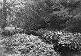
1468 This image has not yet been indexed. Use the Comments button below the image to enter information about the photograph.
Please note: we will not include any personal information provided unless you indicate that you wish to be acknowledged. The standard form for crediting your information is (name, place) e.g. (John Smith, Aberdeen). 
Castle Bridge, Huntly
1723 A postcard image of the Castle Bridge in Huntly over the Deveron River.
On their listed building portal, Historic Environment Scotland describe the bridge as probably 17th century (possibly with earlier fabric) with later strengthening (circa 1800) to the west side.
Their statement of special interest affirms that the Castle Bridge is "an important, early single span bridge in an area of outstanding historic interest, located between Huntly Castle and Huntly Lodge (Huntly Castle Hotel)."
The bridge is also known as Elgin's Bridge. 
Seaton Park
1742 The River Don flows through Seaton Park on its way to the sea. The park, situated in Old Aberdeen in the north of the city, has among other things has been used for horse-racing in the past. 
Town and harbour of Aberdeen
1803 An illustrated view of the town and harbour of Aberdeen, from Balnagask in the south, showing sailing ships on the River Dee.
This illustration looks like a variation on John Slezer's 'New Aberdene from the Block house' from Theatrum Scotiae of 1693. 
New Aberdene from the Block house
1807 John Slezer's illustration showing the town and harbour of Aberdeen from Balnagask in the south.
The view featured in Slezer's Theatrum Scotiae, originally published in 1693.
A blockhouse is a small isolated fort consisting of a single building. The one from the title is shown across the water in the centre of the image. 
Hay's Views of Aberdeen
1810 A view of Aberdeen and the River Dee from the south west by lithographer John Hay and from 1840.
The view shows salmon fishing in the river and linen bleaching activities on the Torry side.
The spires of the South Parish Church, on Belmont Street, St. Nicholas Kirk and the Tolbooth can be seen on the skyline. The Castle Hill Barracks is also clearly visible. |


